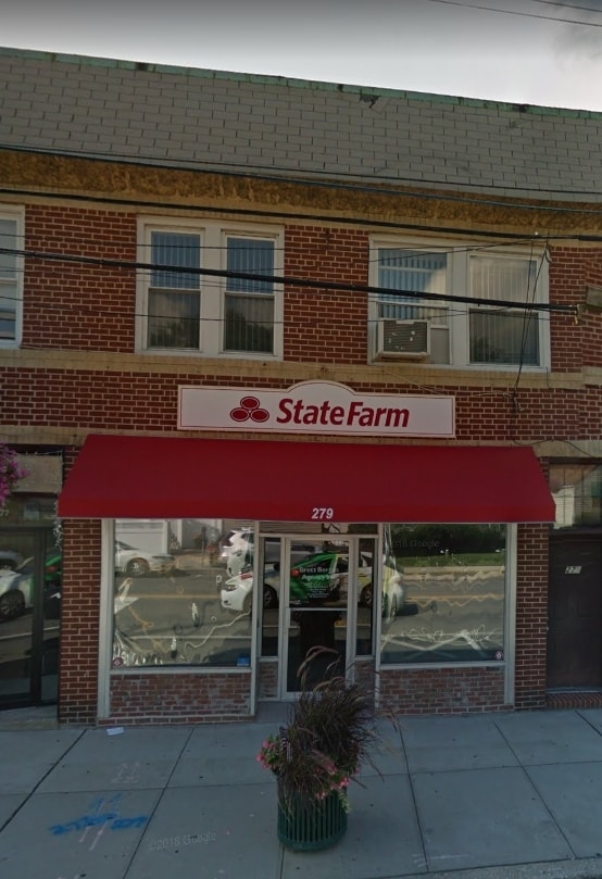
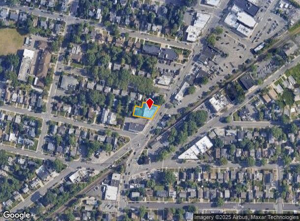
Property Record
277 Hempstead Ave, Malverne, NY 11565
NEARBY LISTINGS FOR SALE OR LEASE
Property Detail
277 Hempstead Ave
2027-37-345-00-0422-0
TOWN #1 SCH DIST 012
Commercialnec
Nassau
X
New York
36059C0216G
422
2025
0.23 AC
2025
Southern Nassau
410100
Long Island (New York)
21,420 SF
Nassau County-Suffolk County, NY
DEMOGRAPHICS near 277 Hempstead Ave
1 Mile
3 Mile
5 Mile
2024 Total Population
26,992
241,546
688,279
2029 Population
26,543
235,612
664,064
Pop Growth 2024-2029
(1.66%)
(2.46%)
(3.52%)
Average Age
42
41
41
2024 Total Households
8,704
77,812
212,313
HH Growth 2024-2029
(1.79%)
(2.55%)
(3.68%)
Median Household Inc
$140,807
$122,355
$113,052
Avg Household Size
3.00
3.00
3.10
2024 Avg HH Vehicles
2.00
2.00
2.00
Median Home Value
$617,432
$632,018
$632,206
Median Year Built
1949
1951
1951
Nearby Places
Map Layers
Map Styles
 Street
 Aerial
- Restaurants
- Banks
- Shops
- Fitness
- Groceries
PUBLIC TRANSPORTATION
TRANSIT/SUBWAY
Malverne Station (West Hempstead Branch - Long Island Rail Road)
DRIVE
WALK
Distance
Malverne Station (West Hempstead Branch - Long Island Rail Road)
1 min
3 min
0.2 mi
Westwood Station (West Hempstead Branch - Long Island Rail Road)
DRIVE
WALK
Distance
Westwood Station (West Hempstead Branch - Long Island Rail Road)
4 min
18 min
0.9 mi
COMMUTER RAIL
Malverne Station (West Hempstead Branch - Long Island Rail Road)
DRIVE
WALK
Distance
Malverne Station (West Hempstead Branch - Long Island Rail Road)
1 min
3 min
0.2 mi
Westwood Station (West Hempstead Branch - Long Island Rail Road)
DRIVE
WALK
Distance
Westwood Station (West Hempstead Branch - Long Island Rail Road)
4 min
18 min
0.9 mi
AIRPORT
John F Kennedy International
DRIVE
WALK
Distance
John F Kennedy International
17 min
9.9 mi
LaGuardia
DRIVE
WALK
Distance
LaGuardia
27 min
16.9 mi
Newark Liberty International
DRIVE
WALK
Distance
Newark Liberty International
54 min
36.7 mi
Freight Ports
NY - Red Hook Container Terminal
DRIVE
WALK
Distance
NY - Red Hook Container Terminal
38 min
21.3 mi
Nearby Properties
Address
Land Use
TOTAL SIZE
Lot Size
Zoning
Address
Land Use
TOTAL SIZE
Lot Size
Zoning
64,618 SF
8.04 AC
Address
Land Use
TOTAL SIZE
Lot Size
Zoning
2,634,357 SF
57.63 AC
Address
Land Use
TOTAL SIZE
Lot Size
Zoning
202.54 AC
Address
Land Use
TOTAL SIZE
Lot Size
Zoning
574,353 SF
65 AC
Address
Land Use
TOTAL SIZE
Lot Size
Zoning
5,800 SF
10.48 AC
Address
Land Use
TOTAL SIZE
Lot Size
Zoning
57,970 SF
1.69 AC
Address
Land Use
TOTAL SIZE
Lot Size
Zoning
130,720 SF
48.60 AC
Address
Land Use
TOTAL SIZE
Lot Size
Zoning
46,404 SF
38.43 AC
Address
Land Use
TOTAL SIZE
Lot Size
Zoning
2,750 SF
235.40 AC
Address
Land Use
TOTAL SIZE
Lot Size
Zoning
29,998 SF
22.49 AC
Address
Land Use
TOTAL SIZE
Lot Size
Zoning
227,776 SF
16.06 AC
Address
Land Use
TOTAL SIZE
Lot Size
Zoning
115.42 AC
Address
Land Use
TOTAL SIZE
Lot Size
Zoning
441,888 SF
22.09 AC
Address
Land Use
TOTAL SIZE
Lot Size
Zoning
23,148 SF
18.67 AC
Address
Land Use
TOTAL SIZE
Lot Size
Zoning
293,443 SF
21.86 AC
Address
Land Use
TOTAL SIZE
Lot Size
Zoning
20,670 SF
6.62 AC
Address
Land Use
TOTAL SIZE
Lot Size
Zoning
88,011 SF
15.01 AC
Address
Land Use
TOTAL SIZE
Lot Size
Zoning
86,903 SF
29.84 AC
Address
Land Use
TOTAL SIZE
Lot Size
Zoning
502,830 SF
1.79 AC
Address
Land Use
TOTAL SIZE
Lot Size
Zoning
140,992 SF
12.07 AC
Address
Land Use
TOTAL SIZE
Lot Size
Zoning
74,813 SF
4.56 AC
Address
Land Use
TOTAL SIZE
Lot Size
Zoning
231,050 SF
15.59 AC
Address
Land Use
TOTAL SIZE
Lot Size
Zoning
88,706 SF
33.61 AC
Address
Land Use
TOTAL SIZE
Lot Size
Zoning
7,172 SF
0.06 AC
R6
Address
Land Use
TOTAL SIZE
Lot Size
Zoning
40,366 SF
17.80 AC
Address
Land Use
TOTAL SIZE
Lot Size
Zoning
59,715 SF
12.81 AC
Address
Land Use
TOTAL SIZE
Lot Size
Zoning
76,396 SF
3.98 AC
Address
Land Use
TOTAL SIZE
Lot Size
Zoning
41,612 SF
3.89 AC
Address
Land Use
TOTAL SIZE
Lot Size
Zoning
117,169 SF
11.64 AC
Address
Land Use
TOTAL SIZE
Lot Size
Zoning
60,892 SF
2.71 AC
The World's #1 Commercial Real Estate Marketplace
Connect with us
© 2025 CoStar Group
The information above has been obtained from sources believed reliable. While we do not doubt its accuracy we have not verified it and make no guarantee, warranty or representation about it. It is your responsibility to independently confirm its accuracy and completeness. Any projections, opinions, assumptions, or estimates used are for example only and do not represent the current or future performance of the property. The value of this transaction to you depends on tax and other factors which should be evaluated by your tax, financial, and legal advisors. You and your advisors should conduct a careful, independent investigation of the property to determine to your satisfaction the suitability of the property for your needs.